-
Seu carrinho está vazio
MENU
- +
-
Todos os produtos
+
- Blog +
- Entregas +
- Pagamentos +
- Contate-nos +
- PROMOÇÕES +
Seu carrinho está vazio
THE SPACECRAFT is approaching the Earth and from above, we can see the ”small ball” getting bigger and bigger. We can identify Europe, Greenland, North Africa, Asia and the Atlantic Ocean. The closer we get, the more we recognise countries. Sweden, Norway, Denmark and Finland are right in front of us, Iceland top left and UK bottom left. Gotland is clearly visible in the Baltic Sea as are the white icecaps in Norway and Iceland.
WE STEER the spacecraft towards Dalarna and suddenly Lake Runn appears with the cities of Falun and Borlänge to the left of the lake and the meandering river Dalälven which is most similar to a long snake. The braking rockets light up and it’s time for landing. The goal is Tjärna Äng school in Borlänge. The white ”football” is visible from the sky. The Dome attracts the pilot’s attention and it is this building we use as the ”last safe” or ”attack point” to find the school as fast as possible.
IN THE UPPER left corner we get a glimpse of a red roof, ”Hemköp”. We focus on the red roof, flying a few laps over the area. We can see the school and the green hill clearly and we land softly on the playground between Hemköp and main building.
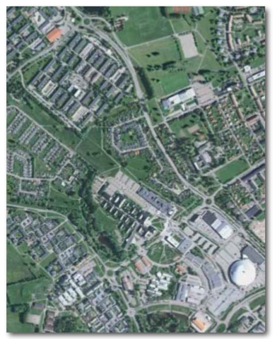
The MAP IS A simplified representation of reality and the smaller the area you want to draw, the more detail you can put on the map. On the Google Earth picture you can see houses and roads very clearly, but you can even discover trees, play equipment and soccer goals. This means that a map of a school and school yard can be very detailed. This is very important when you learn to navigate. What you see in reality is included on the map. The map becomes credible and students trust what the map shows. Having a reliable map is what makes orienteering fun!
ALL MAPS in this booklet are drawn in the international map norm for sprint maps (ISSOM). The colours are logical and easy to understand. All houses are grey, all roads are light brown, lawns are yellow and trees are green. Fences, walls and other manmade objects are black. All that is wet is blue, e.g. lakes, streams, wells and ponds are drawn in blue. The olive green colour denotes private areas and flower beds. More colours and map symbols are described on the following pages.


")

, 30 x 30cm")