-
Teie ostukorv on tühi!
MENU
Teie ostukorv on tühi!
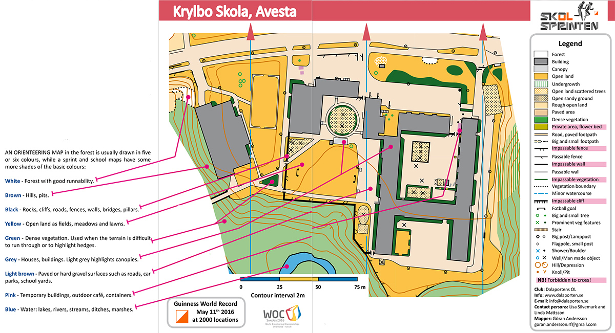
THE LANGUAGE OF THE MAP is international. In the global orienteering world it is important to understand how a map is drawn. The International Orienteering Federation (IOF) has developed an international standard for map drawing where forest maps are drawn to the ISOM (International Specification for Orienteering Maps) norm whilst urban and park maps are drawn based on ISOM but developed into ISSOM ((International Specification for Sprint Orienteering Maps). This standard is generally called “sprint norm” when it is used for orienteering in Sprint, Sprint Relay and Urban races.
SCHOOL MAPS are drawn in the sprint norm (ISSOM) but with the addition of a number of special details that are mostly found in a school yard e.g. lamp post, park bench, small pole (basketball), flagpole, football goal, playground frame, etc. Usually we draw sprint maps at a scale of 1: 4000 or 1: 5000, while the school maps are drawn to scale 1: 1000- 1: 2000 which allows us to include more detail on the map.
ON OUR ScHOOL MAPS we don’t show any scale but only a ”distance ruler”. We think it is difficult for the students to carry a ruler compass in the hand and at same time try to learn orienteering. Silva’s ”Begin” that sits on the wrist helps students to orientate the map easily to the north and the distance ruler provides sufficient information to know the distance between different points.
You are not allowed to run here!
THE MAP’S SYMBOLS
THE MAP’S SYMBOLS are the same throughout the world. A stone is marked as a black dot whether you’re in Sweden, UK, Australia, China or Brazil. The legend to the right of the map shows most map symbols the cartographer is using, but there are more signs and nuances that can be used to make the map even more detailed. For Ages 6-12, we have made it it clearer. Some map characters are highlighted with a pink background. This is important information for both the teachers who prepare the courses and for the students’ participating in the activity.


")

